
The Dominican Republic gives photographers more than palm-lined beaches: it has limestone islands, colonial streets, cloud forests, desert dunes, mountain trails, waterfalls, and remote protected coastlines within one Caribbean country.
This article plan focuses on scenic places that feel visually distinct from one another, with practical timing, access, and cost notes for travelers planning a photo-led route across the Dominican Republic.
Bahia de las Aguilas
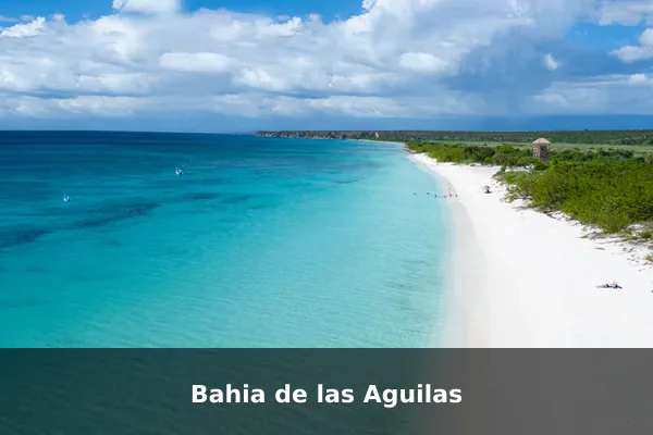
Bahia de las Aguilas is one of the Dominican Republic’s most striking coastal landscapes, with pale sand, transparent water, and an undeveloped horizon that feels rare in the Caribbean.
Photographers can frame wide beach curves, limestone edges, shallow-water color shifts, and minimalist shoreline scenes where the sea and sky carry most of the composition.
Travel tip: Base yourself in Pedernales or nearby Cabo Rojo, and arrange boat or authorized overland access with a local operator before you go.
Best time to visit: Dry season from December to April, ideally early morning or late afternoon for softer light and fewer heat issues.
Ticket price: Access costs vary by boat or 4×4 operator; protected-area fees may apply and should be checked locally.
Los Haitises National Park
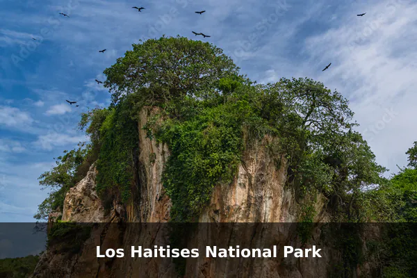
Los Haitises National Park is worth visiting for its cinematic mix of mangrove channels, steep limestone karsts, caves, and water-level views that feel completely different from the country’s beach resorts.
From the boat, visitors can watch for seabirds, study reflections along the mangroves, and photograph cave entrances, rock walls, and green islets rising from the bay.
Travel tip: Use a licensed boat tour from Samana, Sabana de la Mar, or nearby access points, and bring a dry bag for camera gear.
Best time to visit: December to April for generally calmer weather; morning tours usually offer better light and smoother water.
Ticket price: Prices vary by tour operator; park entrance or tour-inclusive fees may apply.
Salto El Limon
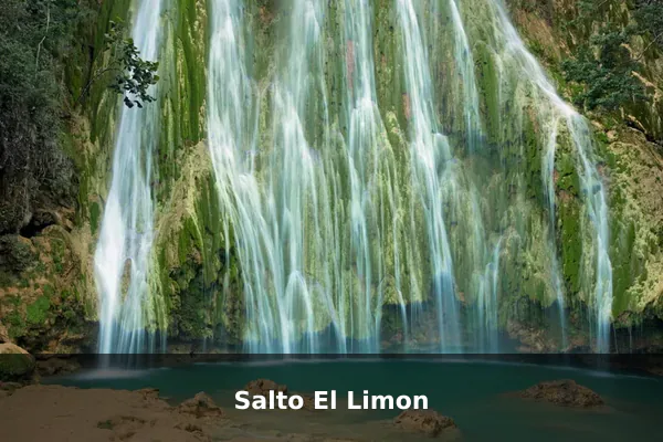
Salto El Limon brings a dramatic jungle mood to a photography route, with a tall waterfall dropping through dense tropical vegetation into a natural pool below.
Visitors can capture mist, wet rock textures, forest light, and swimmers near the base, while slower compositions work well around the trail, river crossings, and shaded greenery.
Travel tip: Wear shoes with strong grip because the trail can be muddy, especially after rain, and protect lenses from spray.
Best time to visit: Morning on weekdays for fewer visitors; the waterfall is usually fuller after rainy periods, though trails may be slippery.
Ticket price: Guide, horse, parking, or trail-access costs vary by entry point and operator.
Playa Rincon
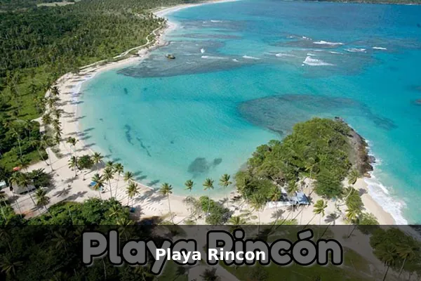
Playa Rincon is a standout Samana shoreline, combining a long sweep of sand with coconut palms, turquoise water, and open views that suit broad, clean coastal panoramas.
Visitors can photograph palm-lined edges, gentle surf patterns, fishing boats, and the changing tones of the bay, then look for quieter details where the beach meets the hills.
Travel tip: Go by rental car, taxi, or boat from Las Galeras, and bring cash because beach services can be limited.
Best time to visit: Early morning for empty beach frames, or late afternoon for warmer light; December to April is usually the most comfortable season.
Ticket price: Beach access is generally free; transport, parking, chairs, food, or boat transfers cost extra.
Laguna de Oviedo
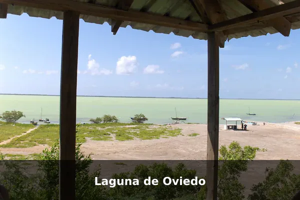
Laguna de Oviedo offers a wilder southwest landscape, where a saltwater lagoon, low islands, dry-country vegetation, and birdlife create layered scenes beyond the usual beach image.
Visitors can look for flamingos, iguanas, distant ridgelines, textured water, and island silhouettes, using a longer lens to isolate wildlife without disturbing the lagoon’s fragile habitats.
Travel tip: Book a guided boat trip and bring a long lens for wildlife, keeping a respectful distance from birds and nesting areas.
Best time to visit: Morning in the dry season, especially when winds are lighter and wildlife viewing is more comfortable.
Ticket price: Boat tours and protected-area fees vary; confirm current rates before visiting.
Hoyo de Pelempito Viewpoint
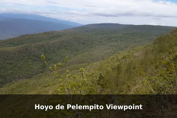
Hoyo de Pelempito Viewpoint rewards the long approach with one of the Dominican Republic’s most dramatic mountain panoramas. From the rim, the land drops into a vast geological basin framed by the rugged Sierra de Bahoruco, creating a scene that feels remote, spacious, and unusually cinematic.
Visitors can photograph layered ridgelines, shifting cloud shadows, and the contrast between dry forest and highland terrain. The overlook is especially strong for wide-angle landscapes, quiet nature observation, and compositions that show the scale of the southwest’s protected mountain country.
Travel tip: Check road conditions before driving, use a high-clearance vehicle when recommended, and bring layers because temperatures can drop at elevation.
Best time to visit: Morning during the dry season for clearer visibility before afternoon haze or cloud builds up.
Ticket price: Protected-area or access fees may apply; current prices should be checked through official park channels or locally.
Dunas de Bani
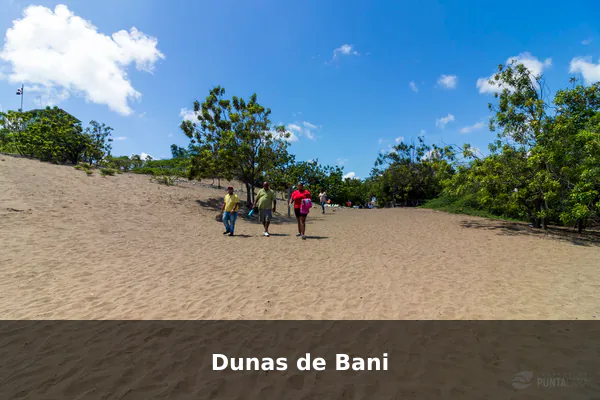
Dunas de Bani is a striking change of mood from the Dominican Republic’s beaches and tropical valleys. Its pale sand ridges, sparse vegetation, and open sky create a rare Caribbean dune setting suited to clean, minimalist photography.
Visitors can work with rippled textures, footprints, silhouettes, and long shadows across the sand. The landscape is best approached slowly, watching how wind patterns, low angles, and distant coastal light turn simple shapes into strong desert-style compositions.
Travel tip: Bring sun protection, water, and lens-cleaning supplies, since windblown sand can be harsh on cameras.
Best time to visit: Sunrise or late afternoon, especially from December to April when conditions are typically drier and cooler.
Ticket price: Entry is often low-cost or locally managed; confirm current access rules and any fee before arrival.
Zona Colonial, Santo Domingo
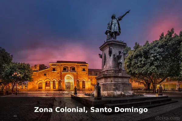
Zona Colonial is one of the country’s richest urban photography areas, where centuries-old streets meet everyday city life. Stone walls, plazas, churches, fortifications, and brightly painted facades give photographers a compact district full of historical texture.
Visitors can frame doorways, balconies, street vendors, shaded arcades, and warm light falling across colonial masonry. It is a place for patient walking, with strong images often found in small details as much as in the landmark views.
Travel tip: Walk early for quieter streets, and be discreet with expensive gear in busy areas after dark.
Best time to visit: Early morning for clean street scenes, or golden hour for warm light on stone buildings; weekdays are usually calmer.
Ticket price: Walking the district is free; individual museums, churches, or heritage sites may charge separate admission.
Montana Redonda
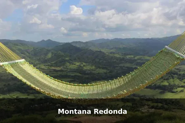
Montana Redonda is popular because its summit opens into a sweeping, circular view of lagoons, coastline, farmland, and distant mountain ridges. The elevated perspective makes it one of the Dominican Republic’s most accessible spots for broad scenic compositions.
Visitors can photograph changing cloud patterns, reflective water, green fields, and layered horizons from several angles around the hilltop. The exposed summit also creates playful motion shots, but the strongest images usually come from watching how light moves across the landscape below.
Travel tip: Use the local truck transfer if the road is rough, and secure hats, scarves, or loose gear because it can be windy at the summit.
Best time to visit: Clear mornings or late afternoon outside peak holiday periods; avoid visiting during heavy rain or low cloud.
Ticket price: Entrance and transport fees vary by operator and season; check current prices before going.
Pico Duarte Trek
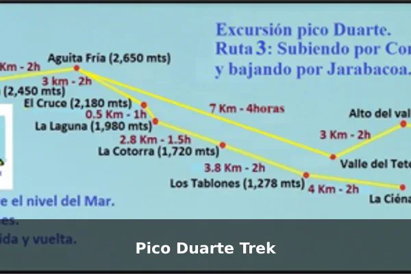
The Pico Duarte Trek is the Dominican Republic’s most demanding scenic photography experience, leading through cool highland forests toward the country’s highest summit. Its appeal lies in the journey as much as the peak, with changing vegetation, mist, and mountain air shaping the atmosphere.
Visitors can document cloud forest trails, rustic camps, mule routes, dawn colors, and wide summit views when weather allows. The trek suits photographers who want a slower, expedition-style story rather than a quick viewpoint stop.
Travel tip: Plan this as a guided multi-day trek with permits, warm layers, rain protection, and enough battery storage for remote conditions.
Best time to visit: December to March for cooler trekking weather and better chances of clear summit views, with sunrise as the key photo moment.
Ticket price: Permit, guide, mule, accommodation, and transport prices vary by route and outfitter.
Official references
- Dominican Republic Ministry of Tourism – Official Tourism Website – Primary tourism-board source for destination names, regions, scenic attractions, and trip-planning context across the Dominican Republic.
- Dominican Republic Ministry of Tourism – Entry Requirements – Official visitor logistics source for passports, e-ticket requirements, visas, customs, and entry rules that should be checked before publishing travel advice.
- Dominican Republic Ministry of Tourism – Pedernales Destination Page – Useful official reference for highly photogenic southwest locations such as Bahia de las Aguilas, Laguna de Oviedo, Hoyo de Pelempito, Jaragua National Park, and Sierra de Bahoruco.
- Dominican Republic Ministry of Tourism – Samana Destination Page – Official reference for scenic photography spots and logistics around Samana Bay, El Limon Waterfall, Cayo Levantado, Playa Rincon, and Los Haitises access.
- Sistema Nacional de Areas Protegidas – Dominican Republic Ministry of Environment – Official protected-areas visitor portal for checking access, tickets, and current park-visit logistics for national parks and reserves.