The Netherlands is compact enough for easy driving, but its best road trips are not about speed. The strongest routes follow dikes, polders, estuaries, heathlands, river valleys, and coastal engineering works where the landscape changes every few kilometers.
This plan avoids a generic city-by-city checklist and focuses on scenic drives, practical stops, and road-friendly experiences that help travelers understand Dutch water management, rural culture, and nature reserves from behind the wheel.
Afsluitdijk and Wadden Center Drive
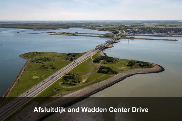
The Afsluitdijk is one of the Netherlands’ most extraordinary feats of engineering, a 32-kilometer causeway slicing across open water to separate the freshwater IJsselmeer from the salty Wadden Sea. Driving it feels like crossing the horizon itself, with sky and water stretching endlessly on either side, making it a defining stop on any Dutch road trip between North Holland and Friesland.
At the midway Afsluitdijk Wadden Center, travelers can explore interactive exhibits about Dutch water management, climate resilience, and the unique Wadden ecosystem, then climb the viewing platform for panoramic shots of the dike vanishing into the distance. Look out for the Vlietermonument marking the dike’s 1932 closure, the modern fish migration river project, and the illuminated Gates of Light sculptures that catch the late afternoon sun.
Travel tip: Check current A7 roadwork and viewpoint access before departure, and only stop at designated parking areas because roadside stopping is unsafe on the dike.
Best time to visit: Late spring to early autumn on a clear weekday morning, ideally between 9:00 AM and noon for wide water views.
Ticket price: Free to drive; visitor center exhibitions, guided tours, or special activities may vary in price.
Zeeland Delta Works and N57 Coastal Causeways
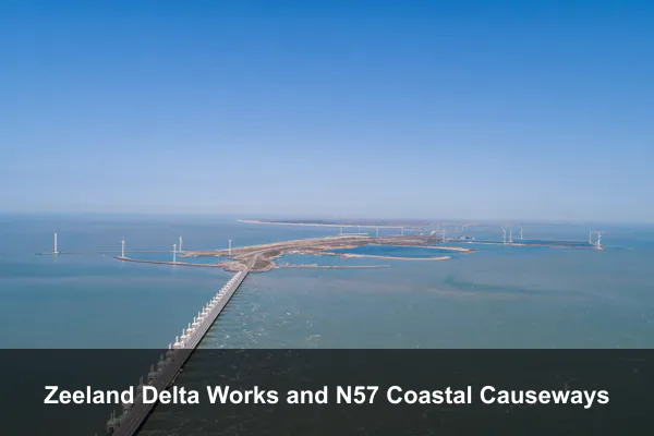
The Zeeland Delta Works stretch ranks among the most striking engineering landscapes in Europe, where the N57 threads across a chain of islands joined by storm surge barriers built after the catastrophic 1953 flood. Driving this coastal causeway delivers a rare mix of open North Sea horizons, wide tidal flats, and monumental concrete piers, giving travellers a vivid sense of how the Dutch reshaped their shoreline to live below sea level.
Along the route, visitors can pull over at the Oosterscheldekering to walk the barrier walkways, explore Deltapark Neeltje Jans for hands-on exhibits and seal feedings, and detour onto Schouwen-Duiveland or Walcheren for dune-backed beaches, lighthouses, and quiet harbour villages. Cyclists share the dike-top paths, kite surfers skim the lagoons, and lay-bys reveal sweeping views of mussel beds, oyster banks, and the slender bridges that knit the delta together.
Travel tip: Build in extra time for Neeltje Jans and beach detours, as wind, bridge openings, and summer traffic can slow the route.
Best time to visit: May to September, preferably on a weekday from late morning to mid-afternoon when coastal light is strongest.
Ticket price: Free to drive; Deltapark Neeltje Jans and guided barrier experiences are paid, with prices varying by season.
Noordoostpolder Tulip Route and Schokland
The Noordoostpolder Tulip Route is one of the Netherlands’ most underrated spring drives, threading through reclaimed farmland that explodes into ribbons of red, yellow, and pink during peak bloom. Unlike the crowded Keukenhof corridor, this northern polder offers wide-open horizons, working flower farms, and a quieter pace that lets you actually pull over and breathe in the scenery. Pairing the route with Schokland adds a rare layer of depth, since this former island sits as the country’s first UNESCO World Heritage Site and tells the dramatic story of land wrested from the Zuiderzee.
Visitors can follow the signposted driving loop between Emmeloord, Creil, and Espel, stopping at designated viewpoints where farms welcome guests for photos, fresh tulip sales, and seasonal tastings. At Schokland, the open-air museum and preserved church mound reveal how communities once lived surrounded by water before the polder was drained, and walking paths trace the old shoreline through quiet farmland. Birdwatchers, cyclists, and history enthusiasts will find side trails branching from the main route, while small village cafés along the way serve as relaxed lunch stops between flower fields.
Travel tip: Use official tulip route maps and never walk into flower fields unless a farm has marked a public photo area.
Best time to visit: Mid-April to early May, weekdays before 10:00 AM or after 4:00 PM for lighter traffic and better photos.
Ticket price: The driving route is free; Museum Schokland and farm activities are paid or vary by operator.
Veluwezoom Posbank Heather Drive
Veluwezoom Posbank Heather Drive winds through the oldest national park in the Netherlands, offering a landscape that feels unexpectedly dramatic for a country known for flatness. Rolling moraines left by Ice Age glaciers create gentle hills that bloom into seas of purple heather in late summer, while ancient beech and oak forests frame long, open vistas rarely found elsewhere in the Dutch countryside.
Visitors can drive or cycle the scenic loop around the Posbank viewpoint, pausing at the café terrace for panoramic views over the heath, or set out on marked trails where red deer, wild boar, and Scottish Highland cattle roam freely. Quiet morning walks reveal misty valleys and birdsong, and the visitor center near Rheden provides maps, ranger-led excursions, and insight into the area’s geology and conservation efforts.
Travel tip: Park at official areas near Rheden or the visitor center, then walk or cycle the most sensitive stretches if car access is restricted.
Best time to visit: Late August to early September for purple heather, or autumn mornings from 8:00 AM to 11:00 AM for color and quiet trails.
Ticket price: Free to enter the national park; parking, guided walks, or visitor center activities may vary.
Mergelland Route in South Limburg
The Mergelland Route in South Limburg breaks every flat-Netherlands stereotype, winding roughly 125 kilometers through rolling hills, half-timbered villages, and pale marl-stone landscapes that feel closer to the Ardennes than the Randstad. It links postcard hamlets like Epen, Slenaken, and Vijlen with hilltop viewpoints, hidden castles, and orchards that explode into blossom each spring, making it the most atmospheric scenic drive in the country.
Along the way travelers can pause for terrace coffee in Valkenburg, explore the underground marl quarries and ruined castle above town, sample Limburgse vlaai in roadside bakeries, and detour to Drielandenpunt where the Dutch, Belgian, and German borders meet. Cyclists share the narrow lanes, cows graze beside sunken hollow roads, and small brown signs marked Mergellandroute guide drivers from one quiet village square to the next.
Travel tip: Drive slowly through village centers and avoid relying only on motorway navigation, as the charm is on the smaller signed scenic roads.
Best time to visit: April to June for blossoms and green hills, or September weekdays from 10:00 AM to 3:00 PM after commuter traffic.
Ticket price: Free to drive; caves, castles, and guided underground tours nearby have separate paid tickets.
Drenthe Hunebed Highway N34 and Borger
The N34, often called the Hunebed Highway, threads through Drenthe past the densest cluster of prehistoric dolmens in the Netherlands, offering a road trip unlike any other in the country. These massive stone tombs, built more than 5,000 years ago by the Funnelbeaker people, sit quietly among heathland, pine woods, and farming villages, giving the drive a sense of deep time that pairs beautifully with Drenthe’s slow, rural rhythm.
In Borger, travelers can stand beside D27, the largest hunebed in the country, and explore the Hunebedcentrum’s exhibits on Neolithic life before following signposted side roads to smaller dolmens near Bronneger, Drouwen, and Havelte. Between stops, the landscape opens into purple heather at Drouwenerzand, sheep grazing on the Ellertsveld, and tidy brick villages where bakeries and terraces invite an unhurried lunch.
Travel tip: Start at the Hunebedcentrum in Borger to understand the sites, then continue to nearby dolmens with sturdy shoes for sandy paths.
Best time to visit: April to October, especially weekday mornings or late afternoons when the stone sites are quieter.
Ticket price: Outdoor dolmens are generally free; Hunebedcentrum entry is paid and prices may change.
Lauwersmeer Dark Sky and Wadden Coast Loop
The Lauwersmeer Dark Sky and Wadden Coast Loop carves through one of the quietest corners of the Netherlands, where former seabed has become a national park certified as a Dark Sky reserve. Its uninterrupted horizons, tidal flats, and reed-fringed lakes make it a rare pocket of true wilderness within an otherwise densely populated country, drawing road trippers who want silence, raw coastal weather, and skies thick with stars rather than crowds.
Drivers can pull off at hides around the Lauwersmeer to spot sea eagles, spoonbills, and vast flocks of geese, then continue along the Wadden dike toward Lauwersoog for ferries to Schiermonnikoog or guided mudflat walks across the salt marshes. After sunset the same pullouts become stargazing spots where the Milky Way is plainly visible, and small harbour villages like Zoutkamp and Moddergat offer fresh fish, maritime museums, and a slow rhythm shaped entirely by the tides.
Travel tip: Bring binoculars, warm layers, and a red-light torch if staying after dark, and check tide and weather conditions in advance.
Best time to visit: Spring and autumn for migratory birds, or clear moonless evenings from September to March for dark-sky viewing.
Ticket price: Free to enter most nature areas; boat trips, excursions, and visitor activities vary in price.
Biesbosch Wetland Drive and Whisper Boat Stop
Biesbosch National Park offers one of Europe’s rare freshwater tidal landscapes, a maze of creeks, willow forests, and reed beds carved by centuries of shifting river deltas. Its quiet driving loops and boardwalk pull-offs make it an easy detour between Dordrecht and Breda, rewarding travelers with sweeping wetland panoramas and the chance to spot beavers, kingfishers, and white-tailed eagles in their natural habitat.
Visitors can stitch together short scenic drives with stops at the Biesbosch MuseumEiland, then glide through the channels aboard silent electric whisper boats that slip past wildlife without disturbing it. Rental kayaks and canoes let you explore narrower creeks at your own pace, while marked boardwalks and observation huts give non-paddlers close-up views of tidal mudflats, blooming water lilies, and the soft rustle of wind through the reeds.
Travel tip: Reserve boat tours or kayak rentals ahead in warm months, and bring insect repellent plus waterproof layers.
Best time to visit: May to September for boating, or April and October on calm weekdays between 10:00 AM and 2:00 PM.
Ticket price: Nature access is free; museum entry, whisper boats, guided tours, and rentals vary by provider.
Westfriese Omringdijk Historic Dike Route
The Westfriese Omringdijk is a 126-kilometer heritage dike that has encircled West Friesland since the 13th century, offering one of the Netherlands’ most authentic road trip experiences through landscapes shaped by centuries of water management. Driving this elevated route reveals a quieter side of North Holland, where former Zuiderzee trading towns like Hoorn, Enkhuizen, and Medemblik sit alongside reclaimed polders and sweeping views over the IJsselmeer.
Travelers can pause in compact harbor towns to wander cobbled streets lined with golden-age merchant houses, visit the Zuiderzeemuseum for open-air maritime history, or stop at small farm stands selling local cheese and produce. The dike itself rewards slow driving with panoramic stretches where lakeside water meets flat green farmland, windmills mark the horizon, and grazing sheep keep the embankment trimmed just as they have for generations.
Travel tip: Split the route with short stops in smaller towns instead of rushing the whole loop, and watch for cyclists on narrow dike roads.
Best time to visit: May to October, especially Sunday morning or weekday afternoons outside peak commuting hours.
Ticket price: Free to drive; museums, heritage attractions, and parking in town centers may require payment.
Sallandse Heuvelrug Holterberg Panorama Road
The Sallandse Heuvelrug Holterberg Panorama Road winds through one of the Netherlands’ rare upland landscapes, offering a quiet eastern alternative to the country’s busier coastal and tulip routes. Its glacial ridges, vast purple heathlands, and dense pine forests create a scenic drive that feels remote despite being easily reached, making it a refreshing detour for travelers seeking calm scenery and clean inland air.
Drivers can pull over at several forest viewpoints and climb the Noetselerberg or Holterberg lookout towers for sweeping views across the Salland plain. Short walking loops lead through fragrant heather where black grouse, sand lizards, and red deer are sometimes spotted, while the visitor center near Nijverdal explains the geology and conservation of this protected national park.
Travel tip: Use official parking areas and stay on marked paths during breeding season to protect sensitive heathland wildlife.
Best time to visit: Late August for heather, October for autumn colors, or early mornings year-round for quieter viewpoints.
Ticket price: Free to enter the national park; parking, visitor center exhibits, or guided activities may vary.