
Austria is often reduced to postcard Alpine views, but its natural landscapes are far more varied than one mountain scene: glacier valleys, old-growth forests, Danube wetlands, steppe-lake bird habitats, limestone gorges, and clear mountain lakes all fit into a compact country. This guide focuses on nature-first places where the scenery is the reason to travel, not just a backdrop between cities.
The recommendations below stay within Austria and balance famous protected areas with practical scenic experiences that reward slow travel. Use the tips to plan transport, choose the right season, avoid the busiest hours, and check which walks are free versus the visitor centers, shuttles, cable cars, or ranger programs that may require paid tickets.
Innergschloess Glacier Trail in Hohe Tauern National Park
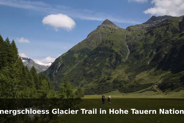
The Innergschloess Glacier Trail sits deep inside Hohe Tauern National Park, Austria’s largest protected alpine area, and offers one of the country’s most accessible introductions to high-mountain scenery without demanding technical climbing skills. The route follows a broad valley framed by 3,000-meter peaks, with views toward the Grossvenediger glacier system that has shaped this landscape for millennia.
Walkers typically start from the Matreier Tauernhaus area and follow signed trails past the Gschloessbach stream, alpine pastures, and seasonal waterfalls toward the Innergschloess hamlet and Venedigerhaus hut. Quiet moments often reveal marmots, ibex, or golden eagles, while interpretive panels and occasional ranger-led walks explain glacier retreat, alpine ecology, and traditional mountain farming in the valley.
Travel tip: Start from Matrei in Osttirol or nearby valley bases and check shuttle, hut, and trail conditions before setting out, as snow can linger high into summer.
Best time to visit: Late June to September, ideally on a clear weekday morning between 8:00 and 11:00.
Ticket price: Trail access is generally free; parking, local shuttle transport, ranger walks, and huts may cost extra and vary by season.
Johnsbach Valley and Enns River Views in Gesaeuse National Park
Gesaeuse National Park in Styria is defined by sheer limestone walls of the Ennstal Alps and the wild, fast-flowing Enns River that cuts through them, and the Johnsbach valley offers one of the most scenic and uncrowded entry points. The combination of dramatic rock faces, mixed mountain forests, and turquoise river bends makes this corner feel both grand and surprisingly intimate compared with Austria’s more famous alpine regions.
From Johnsbach and Gstatterboden, marked paths lead to viewpoints over the Enns gorge, suspension footbridges, and gentler valley walks suitable for families, while more experienced hikers can reach higher meadows and ridges. Visitors may also stop at the historic mountaineers’ cemetery in Johnsbach, watch kayakers on the river from designated points, or join ranger programs focused on wild rivers, forests, and chamois habitat.
Travel tip: Use marked trails from Johnsbach or Gstatterboden and avoid entering riverbanks after heavy rain, when water levels can rise quickly.
Best time to visit: May to October, with September weekdays best for stable hiking weather and fewer visitors.
Ticket price: National park access is generally free; guided ranger programs, visitor services, and parking may have separate fees.
Reichraminger Hintergebirge Forest Trails in Kalkalpen National Park
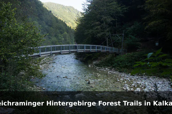
The Reichraminger Hintergebirge forms the wild heart of Kalkalpen National Park in Upper Austria and is one of the largest contiguous forest wilderness areas in the Eastern Alps. Its mix of ancient beech woods, clear karst streams, and remote side valleys provides a quieter, more contemplative alternative to Austria’s high-alpine destinations, with a strong focus on natural forest dynamics.
Long-distance hiking and cycling routes follow former forestry roads deep into the Hintergebirge, passing wooden bridges, small gorges, and meadows where red deer and black woodpeckers are sometimes seen. Visitors can plan day trips from bases such as Reichraming or Molln, combine walking with guided ranger tours on karst hydrology and wildlife, or extend their stay with overnight stops at mountain huts along the way.
Travel tip: Bring offline maps and enough water because mobile reception and refreshment stops can be limited on longer Hintergebirge routes.
Best time to visit: Late May to October; autumn mornings are especially good for forest color and cooler walking conditions.
Ticket price: Outdoor trail access is generally free; ranger tours, exhibitions, parking, or bike services may be ticketed.
Schlossinsel and Danube Wetlands at Donau-Auen National Park
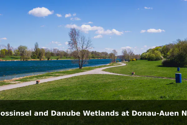
Donau-Auen National Park protects one of the last large free-flowing stretches of the Danube in Central Europe and lies within easy reach of Vienna and Bratislava, making it a rare urban-edge wilderness. The Schlossinsel island at Orth an der Donau acts as a natural showcase of the wider floodplain, with side channels, reed beds, and softwood forest typical of this dynamic river landscape.
At the SchlossORTH National Park Centre, visitors can walk an outdoor circuit past native species such as European pond turtles, sturgeon in display ponds, and kingfishers along the water, while interpretive stations explain the ecology of the Danube floodplain. Boat trips, ranger-guided walks, and cycling along the riverside paths give a fuller sense of how this wetland mosaic supports beavers, white-tailed eagles, and a wide range of fish and amphibians.
Travel tip: Base the visit around Orth an der Donau and book boat or ranger activities ahead in peak season, especially on weekends.
Best time to visit: April to June or September, preferably early morning for wildlife activity and softer light.
Ticket price: Outdoor paths are generally free; SchlossORTH National Park Centre, boat trips, and guided activities require paid tickets with seasonal pricing.
Illmitz Birdwatching Route in Neusiedler See-Seewinkel National Park
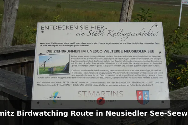
Around the village of Illmitz in Burgenland, Neusiedler See-Seewinkel National Park spreads out as a flat patchwork of shallow soda lakes, salt steppe, reed belts, and traditional pastures on the eastern shore of Lake Neusiedl. This unusual Pannonian landscape lies on a major European flyway, attracting large numbers of migratory and breeding birds and offering some of the widest open horizons in the country.
From the visitor centre and the Hanság road, wooden hides and viewing platforms overlook salt pans such as the Lange Lacke, where visitors can spot avocets, spoonbills, white storks, and seasonal flocks of geese and cranes. Quiet cycling and walking routes connect the hides through grazing landscapes shaped by Hungarian grey cattle, water buffalo, and white donkeys, with guided birding tours available from the national park information centre.
Travel tip: Bring binoculars, sun protection, and windproof layers, then use bicycles or local shuttles to reduce driving between hides and viewpoints.
Best time to visit: Spring and autumn migration seasons, especially sunrise to mid-morning.
Ticket price: Landscape access is generally free; guided birding tours, visitor programs, and equipment rental are priced separately.
Hardegg Viewpoints and Thaya Valley Trails in Thayatal National Park
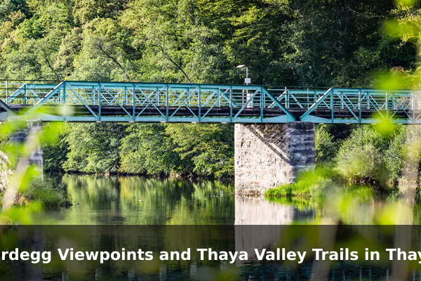
Thayatal National Park protects a compact, deeply incised river valley shared with the Czech Podyji park, where the meandering Thaya carves tight loops through wooded slopes near the small town of Hardegg. The cross-border setting, mixed forests, and historic Hardegg Castle rising above the river give the area a quietly dramatic character that feels distinct from Austria’s better-known alpine destinations.
Visitors can follow well-marked riverside and ridge trails to classic viewpoints over the Thaya meanders, stop at the National Park House for exhibits on local wildlife such as wildcats, and join ranger-led walks when available. The cool, shaded forest sections also reward slow walking, with chances to notice native flora, birdlife, and the layered rock of the valley walls.
Travel tip: Stay on marked paths near the river and carry sturdy shoes, as shaded forest sections can remain damp and slippery.
Best time to visit: May to October, with late spring for fresh greenery and early autumn for quieter trails.
Ticket price: Hiking trails are generally free; National Park House exhibits, ranger walks, and special programs may have separate fees.
Grosser Ahornboden in Karwendel Nature Park
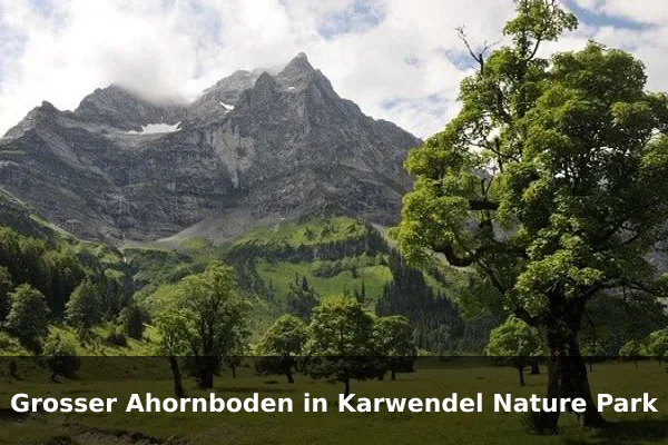
The Grosser Ahornboden is a high alpine pasture in the Eng valley of Tyrol’s Karwendel range, famous for hundreds of ancient sycamore maples scattered across open meadows beneath sheer limestone walls. In autumn the maples turn deep gold and orange, creating one of Austria’s most photographed mountain landscapes, while summer brings grazing cattle and a calmer pastoral mood.
From the Eng, gentle paths loop among the maples and lead to nearby alpine huts, while longer routes climb toward Karwendel viewpoints and protected high-mountain terrain. The Naturparkhaus offers context on the park’s geology, forests, and traditional alpine farming, and visitors can pause for regional food at the huts before exploring further into the valley.
Travel tip: Arrive early or use regional transport where available because the Eng valley road and parking areas can fill quickly on fine autumn days.
Best time to visit: Late September to mid-October for maple color, or June to September for hiking and alpine pasture scenery.
Ticket price: Walking access is generally free; road tolls, parking, Naturparkhaus admission, and hut services may cost extra.
Ginzling and Zemmgrund in High Alps Nature Park Zillertal Alps
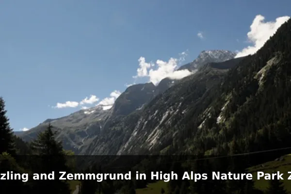
Ginzling is the mountaineering village at the heart of the High Alps Nature Park Zillertal Alps, opening into the Zemmgrund, a long protected valley that climbs toward glaciers, three-thousand-metre peaks, and a chain of classic alpine huts. The combination of strict protection, deep glacial scenery, and good local bus links makes it a strong choice for travellers who want a genuine high-mountain experience without private transport.
From Ginzling, hikers can ride seasonal buses deeper into the Zemmgrund and walk to huts such as those around the Berliner Hoehenweg, while easier valley paths follow streams through larch and stone-pine forest. The nature park information centre helps with route planning, hut bookings, and guided programs that highlight glaciers, alpine flora, and traditional land use in the Zillertal.
Travel tip: Plan routes from Ginzling and check bus timetables carefully, as late return options can be limited outside peak hiking season.
Best time to visit: July to September for high trails; June and early October are better for lower valley walks.
Ticket price: Trail access is generally free; guided nature park programs, buses, huts, and any nearby lifts outside the protected core vary in price.
Oetschergraeben Gorge in Oetscher-Tormaeuer Nature Park
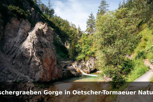
The Oetschergraeben is one of Lower Austria’s most striking gorge walks, threading along the Oetscherbach beneath the limestone bulk of the Oetscher in the Oetscher-Tormaeuer Nature Park. Clear pools, small waterfalls, and narrow rock passages connected by wooden walkways and bridges give the route a varied, almost canyon-like feel that stands out among Austria’s lower-altitude scenic places.
Walkers typically start from Wienerbruck or Mitterbach on the Mariazellerbahn line and follow the gorge past the Mirafall waterfall, with options to extend to the Oetscherhias hut or loop back via higher forest paths. Along the way visitors can notice clinging mosses and ferns, trout in shaded pools, and interpretive signs that explain the area’s karst geology and protected habitats.
Travel tip: Wear grippy footwear and consider arriving by Mariazellerbahn to Wienerbruck or Mitterbach, as parking is limited on busy hiking days.
Best time to visit: May to October, ideally on dry weekdays after morning departure when the gorge is quieter.
Ticket price: The park lists a nature park entrance fee, commonly around EUR 5 for adults and EUR 2 for children 6-14; parking is extra and prices can change.
Vorderer Gosausee Lake Loop in the Salzkammergut
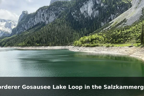
The Vorderer Gosausee is a clear alpine lake in the Salzkammergut that mirrors the glaciated Dachstein massif and the jagged Gosaukamm on calm mornings, making it one of Austria’s most recognisable mountain views. Its easy access, short circular path, and combination of lake, forest, and high peaks suit travellers looking for big scenery without a demanding hike.
A roughly two-hour loop follows the shoreline through larch and spruce, with constantly changing perspectives on the Dachstein glaciers and rocky ridges above. Visitors can extend the visit with a ride on the Gosaukamm cable car for higher viewpoints, rent a rowing boat in season, or continue on connecting trails toward the more remote Hinterer Gosausee for a longer day in the mountains.
Travel tip: Visit early before tour buses arrive, and bring a light layer because the lakeside can feel cool even on sunny summer mornings.
Best time to visit: May to October, with sunrise or early morning best for reflections and quieter paths.
Ticket price: Lakeside access is generally free; parking, boat rental, and the Gosaukamm cable car are separate and seasonally priced.
Official references
- Austrian National Tourist Office – Official national tourism source for Austria destination inspiration, seasonal travel ideas, sustainable travel, and visitor guidance.
- National Parks Austria – Official umbrella source for Austria's national parks, useful for park overviews, protected-area context, visitor experiences, and links to individual park administrations.
- Association of Austrian Nature Parks – Official source for Austria's nature parks, including the national directory and background on the Nature Park designation.
- Austrian Environment Agency – National Parks – Primary environmental-agency reference for protected areas and national park classification in Austria.
- Hohe Tauern National Park – Official park source for Austria's largest national park, with current visitor and nature information for alpine scenic destinations.